davin.50webs.com/frank
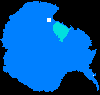
Tararua Antarctic expedition (1962-1963).
Main Menu
Mount Pearson
Antarctic Expedition
Antarctica Ahoy!
Around Scott Base
Expedition Begins
Exploration Area
Exploration Routes
Plateau Loop Map
Polar Plateau
Icy Panorama
East Quartzite Range
West Quartzite Range
Upper Glacier
Glacier Route
Middle Glacier
Lower Glacier
Final Stretch
Destination
Conclusion
Diary: Introduction
Diary: Preparation
Diary: Polar Plateau
Diary: Quartzite Xmas
Diary: Into the Glacier
Diary: Home Run
Appendix: Polar Life
Appendix: Logistics
Appendix: Mapping
Acknowledgements
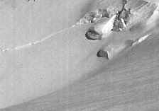
Upper Pearl Harbour Glacier
Upper Pearl Harbour Glacier from Toboggan Gap. 3 January 1963.
On the skyline at the far left stands Mt. Tararua, 2548 m.
Two days before, John Millen�s team climbed it.
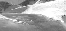
Gerald prepares to sledge from Toboggan Gap
into the Upper Pearl Harbour Glacier.
Left: Gerald views Turret Peak, south of Toboggan Gap.
Right: From Toboggan Gap, the upper glacier sloped up to 35�.
Rope brakes wound around the sledge runners helped control the sledge.
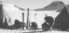
The sledging route threads between icefalls.
Toboggan Gap 15 km behind, from Camp X. 3 January.
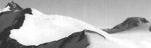
From survey station YY2 along a ridge to Turret Peak.
Toboggan Gap is visible to the right. 4 January.
Upper Pearl Harbour Glacier towards Toboggan Gap,
during the descent from station YY2.
Slogging through soft snow in the Middle Pearl Harbour Glacier.
Survey station YY2 and LeCouteur Peak
lie on ridge lines to the left and right respectively.
The Upper Pearl Harbour Glacier
is the tongue of ice entering between YY2 and LeCouteur.
Glacier Route
Back to Antarctica
|
Main Menu
|
Mount Pearson
|
Antarctic Expedition
|
|
|
|
Antarctica Ahoy!
|
Around Scott Base
|
Expedition Begins
|
Exploration Area
|
Exploration Routes
|
|
Plateau Loop Map
|
Polar Plateau
|
Icy Panorama
|
East Quartzite Range
|
West Quartzite Range
|
|
Upper Glacier
|
Glacier Route
|
Middle Glacier
|
Lower Glacier
|
Final Stretch
|
|
Destination
|
Conclusion
|
Diary: Introduction
|
Diary: Preparation
|
Diary: Polar Plateau
|
|
Diary: Quartzite Xmas
|
Diary: Into the Glacier
|
Diary: Home Run
|
Appendix: Polar Life
|
Appendix: Logistics
|
|
Appendix: Mapping
|
Acknowledgements
Last modified: Wed Mar 4 17:41:33 NZDT 2020
Best viewed at 1024x768 or above resolution.
© Copyright 1999-2020 Davin Pearson.
Please report any broken links to