davin.50webs.com/frank
Tararua Antarctic expedition (1962-1963).

Main Menu Mount Pearson Antarctic Expedition
Antarctica Ahoy! Around Scott Base Expedition Begins Exploration Area Exploration Routes
Plateau Loop Map Polar Plateau Icy Panorama East Quartzite Range West Quartzite Range
Upper Glacier Glacier Route Middle Glacier Lower Glacier Final Stretch
Destination Conclusion Diary: Introduction Diary: Preparation Diary: Polar Plateau
Diary: Quartzite Xmas Diary: Into the Glacier Diary: Home Run Appendix: Polar Life Appendix: Logistics
Appendix: Mapping Acknowledgements


Polar Plateau

Two men pull a sledge by waist harnesses. 
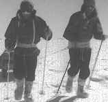
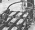
Evan and John haul their 300 kg sledge.

A mile an hour (1˝ kph) is a brisk pace on the flat.
Uphill man-hauling is slower and exhausting.

Alan Beck of the 1957-58 Tucker Glacier Expedition
said of man-hauling:
"Shut yourself off from the world,
and heave each step in a trance.
Don't count minutes or watch the country,
as both pass so slowly."

Lunch group on the polar plateau. Lunch drink from a vacuum flask. 
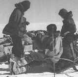
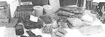
Lunch break from man-hauling. 10 December.
We marched for 50 minutes per hour,
resting for an hour at lunch.

Long, strenuous days in the cold, dry air
made us thirsty. Vacuum flasks kept beverages
from freezing. Half-liter flasks proved rather
small, so we drank copiously at camp.

Food boxes and equipment lashed to the sledge. The Nansen sledge is a wooden frame on ski runners. 
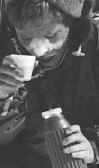
The sledge carried a 300 kg load:
food, tent, bedding, clothing,
personal items, equipment for
camping, climbing and surveying,
and a radio transceiver.

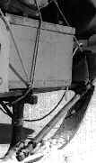
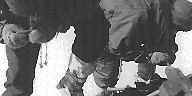
Norwegian-designed Nansen sledges
have wooden members lashed together,
a resilient construction.

Food items from a 20-man-day ration box.

Each 20-man-day standard ration box held 16˝ kg of food:
dehydrated meat, vegetables, soup, egg, milk and beverages,
as well as pemmican, bacon, oatmeal, Tararua lunch biscuits,
tinned butter from Argentina, Nestlé's chocolate and toilet paper.

Geologists scour the area for rocks of interest.

Geological team Evan Leitch and John Hayton at work,
near survey station H2. 13 December. Camp III.

Geological mapping and navigation
rely on a magnetic compass for direction.

Near the south magnetic pole the earth’s magnetic field is faint,
so the magnetic compass was of little use,
which hampered both scientific work and navigation.

Icy Panorama
Back to Antarctica
| Main Menu | Mount Pearson | Antarctic Expedition | | |
| Antarctica Ahoy! | Around Scott Base | Expedition Begins | Exploration Area | Exploration Routes |
| Plateau Loop Map | Polar Plateau | Icy Panorama | East Quartzite Range | West Quartzite Range |
| Upper Glacier | Glacier Route | Middle Glacier | Lower Glacier | Final Stretch |
| Destination | Conclusion | Diary: Introduction | Diary: Preparation | Diary: Polar Plateau |
| Diary: Quartzite Xmas | Diary: Into the Glacier | Diary: Home Run | Appendix: Polar Life | Appendix: Logistics |
| Appendix: Mapping | Acknowledgements
Last modified: Wed Mar 4 17:41:33 NZDT 2020
Best viewed at 1024x768 or above resolution.
© Copyright 1999-2020 Davin Pearson.
Please report any broken links to